

- Watch out
- What it costs
- Experienced readers
- Remember
- In BIMpedia
On a building you locate things by grids and levels. On a road, a railway or a pipeline you locate them by how far along the line they are, and how far to the side. That line is the alignment, and the distance along it is the chainage.
| Term | Meaning |
|---|---|
| Horizontal alignment | The line in plan: straights, circular curves, transition curves |
| Vertical alignment (profile) | Levels along the line: grades and vertical curves |
| Chainage / stationing | Distance along the alignment from its start |
| Offset | Distance left or right of the alignment, at right angles |
| PI | Point of intersection, where two straights or two grades meet |
How chainage is written
| Where | Written | Means |
|---|---|---|
| US (feet) | Sta. 5+10 | 510 ft |
| Metric | Ch 1+250 or 1+250.000 | 1 km and 250 m = 1,250 m |
| UK railways (traditional) | 12 m 40 ch | 12 miles 40 chains (1 chain = 22 yards ≈ 20.12 m) |
A structure on the line is located as "chainage, offset": for example Ch 2+340, 4.5 m left.
A real profile
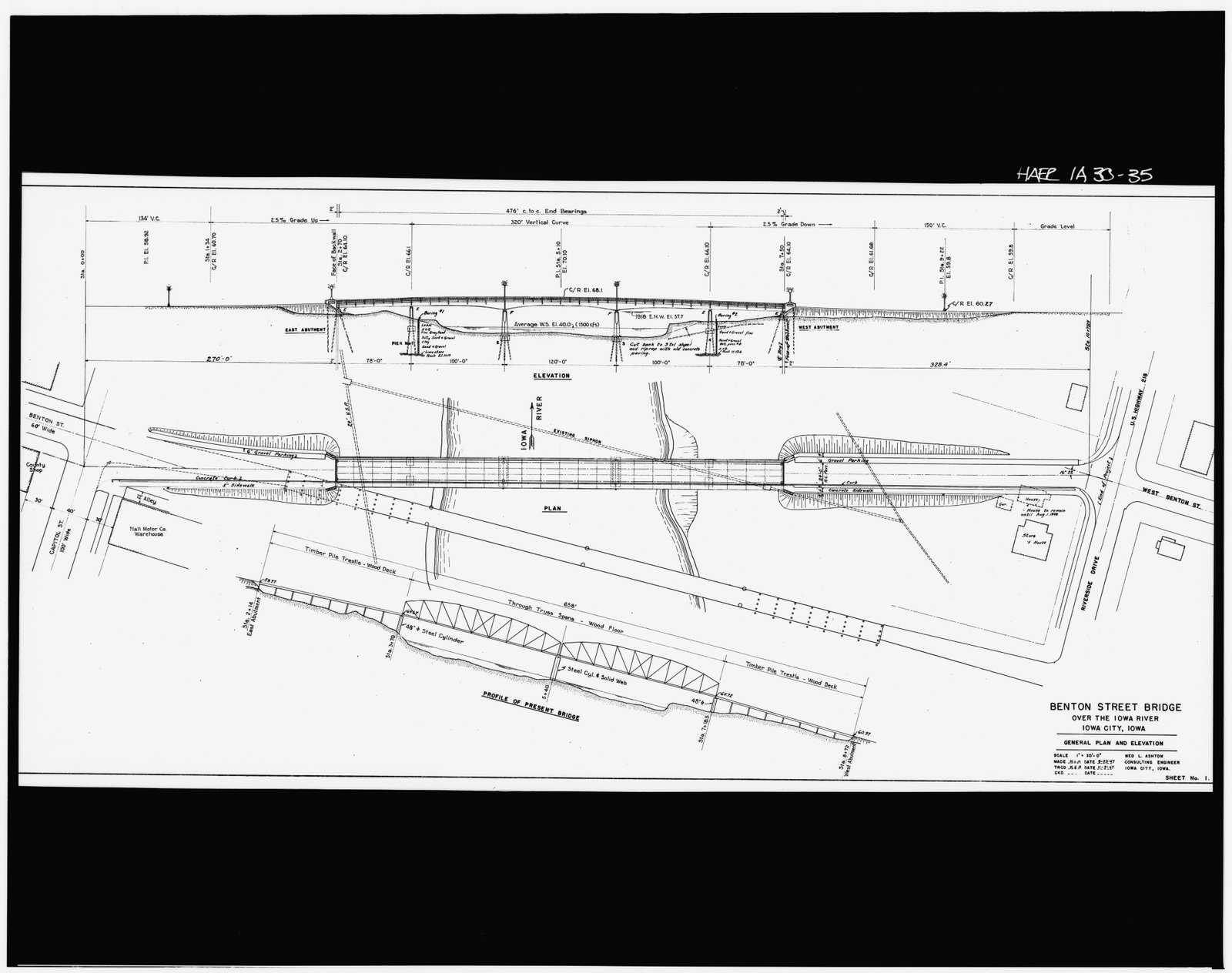
Sheet 1 of the Benton Street Bridge. The elevation is a profile along the road: stations from Sta. 0+00, a 2.5% grade up, a 320 ft vertical curve with its PI at Sta. 5+10, El. 70.10, and a 2.5% grade down.
Benton Street Bridge, Iowa City (Ned L. Ashton, consulting engineer, 1947–48). Historic American Engineering Record, HAER IOWA,52-IOWCI,4-. Library of Congress, Prints and Photographs Division. Public domain. Source
The elevation on sheet 1 is a profile along Benton Street. It gives stations (the east backwall face at Sta. 2+70, the west one at Sta. 7+50), the grades (+2.5% up and −2.5% down) and a 320 ft vertical curve with its PI at Sta. 5+10, El. 70.10. The crown of the road at midspan is written as El. 68.1. In the exercise you'll check that number yourself.
Alignments in open BIM
IFC 4.3 adds IfcAlignment, with its horizontal, vertical and cant (for rail) parts, so a bridge or a station can be placed by its position along the alignment and exchanged with that reference intact. Before IFC 4.3, alignments travelled mostly in LandXML or in each vendor's own format.
Culverts are located in the drainage schedule only by chainage. The road alignment is redesigned around a new junction and becomes 40 m longer before the river. The schedule isn't updated; the culverts are set out at their old chainages, 40 m short of the watercourses they were meant to carry.
The drainage schedule records each culvert's chainage with the alignment name and revision, and its coordinates. When the alignment changes, a check flags every item referenced to the old revision, and the culverts are re-chained before anything is set out.
From sheet 1 of the Benton Street Bridge: grades of +2.5% and −2.5% meet at a PI at Sta. 5+10, El. 70.10, with a 320 ft symmetrical vertical curve.
- At which stations does the vertical curve start and end?
- What is the level of the road at the middle of the curve? Compare with the drawing.
- How far from the PI is the high point?
Key takeaways
- An alignment is a horizontal line (straights, curves, transitions) plus a vertical profile (grades and vertical curves).
- Chainage or stationing is the distance along it; offsets are left or right of it.
- US stations are written in hundreds of feet (Sta. 5+10 = 510 ft); metric chainage in kilometres and metres (Ch 1+250).
- A chainage only means something with its alignment name and revision; IFC 4.3 carries alignments as IfcAlignment.